Hiking 74km in two days and the last two mile beaches on Australian mainland complete.
| General Location | Wilson Promontory National Park |
|---|---|
| Aboriginal Tribe/Language Group | Kulin People – the Boonwurrung and Woiwurrung, Yiruk |
| Access to beach | Bush walking trail |
| Beach Classification | Wave Dominated – Intermediate – Traverse Bar & Rip |
| Start Date/Time | 7 August 2019 14:12 (3 Mile Bch) 8 August 2019 08:50 (5 Mile Bch) |
| Start Location (inc Lat/Log) | S38° 52.695’ E146° 28.269’ (3 Mile Bch) S38° 54.966’ E146° 28.449’ (5 Mile Bch) |
| End Date/Time | 7 August 2019 15:11 (3 Mile Bch) 8 August 2019 10:49 (5 Mile Bch) |
| End Location (inc Lat/Log) | S38° 50.577’ E146° 28.486’ (3 Mile Bch) S38° 58.876’ E146° 26.166’ (5 Mile Bch) |
| Mode of Travel | Hike |
| Distance Travelled | Hiked total 74 km (3 Mile bch-4.1km/5 Mile bch-7.9km) |
| Location of Sand Sample (lat/Long) | S38° 51.636’ E146° 28.117’ (3 Mile Bch) S38° 57.035’ E146° 26.941 (5 Mile Bch) |
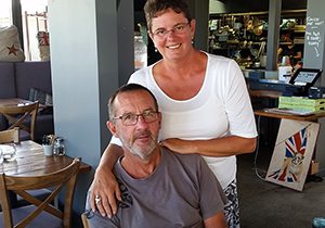
Wilson Promontory mile beaches have been in the planning for a very long time. Initially I had intended to attempt the beaches in April 2017, but event transpired to postpone until August 2019. I am so glad it happened as this allowed a very important person to join me, Matthew my son.
Matthew by participating in the hike into the northern section of Wilson Promontory means that every one of our siblings has become a member of the Mile Beach Club. The other two siblings Renee – One Mile Beach, Anne Bay NSW, and Nathan – Three Mile Beach, Horrick WA. Their participation certainly spread out far around the country.
The hike into the beaches started on Tuesday night. We arrived at the Wilson Promontory carpark at 9:30pm. We had set ourselves a rather difficult task, complete the hilly journey to and from the coast, walk the two beaches in just two days total 74km. Although I had made a lot of enquiries and lots of research, the track condition and terrain were a bit of an unknown also the weather forecast was not the best.
We camped the first Tuesday night at Barry Creek Campsite exactly 6 km along the walking track pitching our tent at about 11:30pm. Up early the next morning we made it safely to the 5 Mile Beach Campsite by midday and setup camp. After a hearty lunch we heading off along the trail to 3 Mile Beach. The 6 km walking trail to reach 3 Mile Beach was marked on the Wilson Promontory Map but it was completely overgrown and in some parts required bashing our way forward through coastal tea tree scrub. It was very hard going in parts but we got to and completed 3 Mile beach. Because of the delay in bush basing our way we didn’t return to Miranda Creek until 7:30pm well after sunset, and as it was heavily overcast it was pitch black dark. To make matters worse the knee deep creek crossing we had experienced on the way out earlier that day was now chest deep due to a king high tide that evening. With no options of finding any crossing further up we had to strip off and in the dark with cloths and packs above our heads cross the creek in the dark. Lucky our campsite was only 50 metres on the other side of the creek so a quick towel down and into dry clothes warded off any hypothermia.
The next morning we woke to heavy rain but luckily it was all over by 7:30am and we quickly packed up camp, eat breakfast then walked 5 Mile Beach. By midday we were back hauling packs back up the 18km track to our car arriving at 5:30pm just as the sun was setting. Our decision to push through and finish Thursday night was justified when that night southern Victoria was hit by some extremely wild storms.
Thanks Matt it was so special to have you with me.